

Coastal
inundation

Coastal inundation happens when high tides, storms, or big waves push water into low-lying areas, putting homes, businesses, and places people enjoy by the sea at risk.
In Pōneke | Wellington, rising sea levels, extreme weather, and how we use land along the coast make this problem worse, showing the strong effects of climate change on our coastline. The case studies below illustrate the ever-changing nature of the land and sea, highlighting the growing risks and the need for future-focused planning.
Our harbour – changing foreshore and waterways
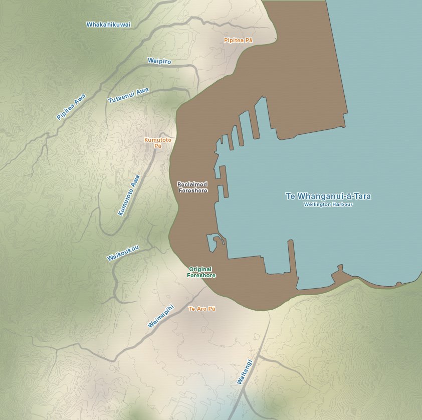
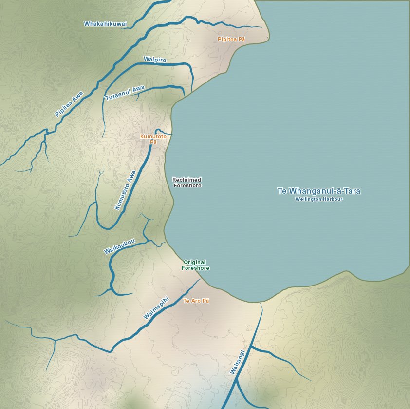
Drag the slider to explore how the original foreshore has been modified, and rivers and streams have been piped underground, since the early 1800s.
In the early 1800s, mana whenua, Taranaki Whānui ki te Upoko o te Ika (that is the collective of Taranaki tribes that had migrated from Taranaki), had pā and kāinga all around Te Whanganui-a-Tara - later also known as Pōneke | Wellington. These pā were usually also positioned next to important awa (rivers and streams).
Being positioned close to rivers and the sea provided ready access to food and water; means of travel and trade; and places and to undertake various cultural practices and activities. People, lands and waterways living in balance.
In 1839, the New Zealand Company arrived in the harbour, marking the beginning of colonial settlement and rapid urbanisation. At that time, there were three major Taranaki Whānui pā in what has become the Wellington CBD area. They were all located close to the original foreshore (since reclaimed), and important awa (since piped underground).
These pā, shown in the maps are: Pipitea (Te Atiawa ) centered close to where modern day Pipitea marae is; Kumutoto (Te Atiawa) centred around modern day The Terrace/ Woodward Lane); and Te Aro (Taranaki iwi and Ngāti Ruanui), centred around modern day Taranaki St/Courtenay Place and the extended city areas still known as Te Aro today.
Our city’s shoreline was changed significantly over the last 170 years or so with a series of land reclamations at the harbour’s edge.
The many awa of the city area have also been piped underground at both the areas of foreshore reclamation and further inland.
The combination of reclaiming land at the foreshore and piping rivers underground can contribute to risks of coastal inundation and dry day flooding.
These actions, alongside the many other impacts of rapid colonial settlement at Te Whanganui-a-Tara has disrupted the important relationships between people, lands and waterways with impacts being felt by mana whenua, tangata whenua and tangata tiriti living in the city today.
Pre-colonisation
Post colonisation
Disrupting the flow of our lives
Some key roads in Motukairangi are close to the shoreline. Sea level rise combined with more frequent and severe storms is likely to bring water onto our roads. This could cause damage and inconvenience. It might mean being isolated from the people, places, and activities that shape daily life and wellbeing. Links between suburbs could be blocked. Water on coastal roads in Motukairangi could also affect access in and out of the airport.
This visualisation shows some key roads in areas at medium and high risk of coastal inundation. Some of the services and activities these roads connect us to are highlighted by icons.
The scene

Sand dunes come down, buildings go up
Before colonial settlement of Hue-te-Para beach | Lyall Bay, a large field of tall sand dunes stretched inland from the sea for about 100 meters. It protected low-lying land from flooding.
In the early 1900s, people decided to break down the sand dunes at the shore. Some dunes were removed completely. Others were modified so houses and other structures could be built on top of them, on land that is naturally not much higher than the sea level.


After
Before
Wellington City Council archives photographs.
We love to be beside the sea
The beauty and expanse of the moana in Motukairangi makes the coast a popular place to live, work, and play. When rising seas, storm surges and tidal pressure cause flooding in buildings and homes, the impacts on people’s lives can be extreme and long lasting.
There are immediate risks to health and safety, plus longer-term issues like damp homes, salty soil, and economic stress relating to repairs, maintenance and insurance.

Image supplied by Wellington Region Emergency Management Office (WREMO)
The scene
Data visualised shows areas at high risk of coastal inundation due to severe weather events and sea level rise.
Learn more about climate disruption in Pōneke | Wellington

Over time, natural waterways have been drained, piped, and covered as people built businesses, roads and homes around Pōneke | Wellington.
Flooding


The hills and cliffs of Pōneke | Wellington create an interesting, beautiful landscape. But living above and below steep slopes can come with risks too.
Landslides

Learn more about planning for and preventing climate disruption

Adaptation options
Planning for climate disruption starts with understanding what our options are to increase the city’s resilience.

Take action
Working together, we can protect the people and places we love in in Pōneke | Wellington, now and into the future.